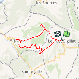
![](/images/other/stat-length.png)
![Tocht Mountainbike Le Poët-Sigillat - La Grande Javonière - Photo](https://media.geolcdn.com/t/1900/400/ext.pjpeg?maxdim=2&url=https%3A%2F%2Fservices.sitytrail.com%2FGeolivesWS%2FDownloadMedia.ashx%3FTrailID%3D103221%26Media%3D5104_6.jpg)
La Grande Javonière
tracegps
Gebruiker
![Lengte](/images/other/stat-length.png)
![Max. hoogte](https://static1.geolcdn.com/siteimages/upload/files/1508320355ic_sort_altitude_max_24dp.png)
![Positief hoogteverschil](https://static1.geolcdn.com/siteimages/upload/files/1508320355ic_sort_den_pos_24dp.png)
![Km-Effort](/images/other/stat-length.png)
![Min. hoogte](https://static1.geolcdn.com/siteimages/upload/files/1508320355ic_sort_altitude_min_24dp.png)
![Negatief hoogteverschil](https://static1.geolcdn.com/siteimages/upload/files/1508320355ic_sort_den_neg_24dp.png)
![Boucle](https://static1.geolcdn.com/siteimages/upload/files/16400158638029165_repeat_loop_refresh_sync_direction_icon.png)
![Mountainbike](https://static1.geolcdn.com/sitytour/trail-icons/202.png)
2h00
Moeilijkheid : Moeilijk
![Scan deze QR-code om de tocht te openen in de SityTrail-applicatie](https://capi.geolives.com/qq0zvz2zws4bq2lad0pu/sitytour/trails/103221/qr.png?size=200)
Gratisgps-wandelapplicatie
Over ons
Tocht Mountainbike van 13,9 km beschikbaar op Auvergne-Rhône-Alpes, Drôme, Le Poët-Sigillat. Deze tocht wordt voorgesteld door tracegps.
Beschrijving
Belle balade entre deux beaux villages, le Poët sigillat et Arpavon aux parfums de lavande. Première partie en sentiers avec une belle descente vtt sur Arpavon. Deuxième partie sur piste. C'est une rando casse-croûte, plus de détails au gîte du Pré bossu.
Plaatsbepaling
Opmerkingen
Wandeltochten in de omgeving
![Tocht Stappen Sahune - 26 sahune - Photo](https://media.geolcdn.com/t/375/260/a180cf7c-fb96-48c2-9d7c-76f8ea234985.jpg&format=jpg&maxdim=2)
![Stappen Stappen](https://static1.geolcdn.com/sitytour/trail-icons/101.png)
Stappen
![](/images/other/stat-length.png)
![](https://static1.geolcdn.com/siteimages/upload/files/16400158638029165_repeat_loop_refresh_sync_direction_icon.png)
![Tocht Stappen Rémuzat - les Aiguilles en partant de Remuzat - Photo](https://media.geolcdn.com/t/375/260/8caa209c-8d1c-426d-8ea8-486025dba5cb.jpg&format=jpg&maxdim=2)
![Stappen Stappen](https://static1.geolcdn.com/sitytour/trail-icons/101.png)
Stappen
![](/images/other/stat-length.png)
![](https://static1.geolcdn.com/siteimages/upload/files/16400158638029165_repeat_loop_refresh_sync_direction_icon.png)
![Tocht Stappen Sahune - rocher de Bramard - Photo](https://media.geolcdn.com/t/375/260/b6e96133-4660-4d7a-bbea-eb48a170bb19.jpg&format=jpg&maxdim=2)
![Stappen Stappen](https://static1.geolcdn.com/sitytour/trail-icons/101.png)
Stappen
![](/images/other/stat-length.png)
![](https://static1.geolcdn.com/siteimages/upload/files/16400158638029165_repeat_loop_refresh_sync_direction_icon.png)
![Tocht Stappen Sahune - Sahune - Photo](https://media.geolcdn.com/t/375/260/ext.jpg?maxdim=2&url=https%3A%2F%2Fstatic1.geolcdn.com%2Fsiteimages%2Fupload%2Ffiles%2F1553511878bg_sport_marche.png)
![Stappen Stappen](https://static1.geolcdn.com/sitytour/trail-icons/101.png)
Stappen
![](/images/other/stat-length.png)
![](https://static1.geolcdn.com/siteimages/upload/files/16400158638029165_repeat_loop_refresh_sync_direction_icon.png)
![Tocht Noords wandelen Rémuzat - Tour du Montrond - Photo](https://media.geolcdn.com/t/375/260/52f37003-9d49-438e-b061-694c5d6432f0.jpg&format=jpg&maxdim=2)
![Noords wandelen Noords wandelen](https://static1.geolcdn.com/sitytour/trail-icons/102.png)
Noords wandelen
![](/images/other/stat-length.png)
![](https://static1.geolcdn.com/siteimages/upload/files/16400158638029165_repeat_loop_refresh_sync_direction_icon.png)
![Tocht Stappen Rémuzat - rocher du caire - Photo](https://media.geolcdn.com/t/375/260/60db15ec-1b2a-4873-b1d2-ea69db9a6899.jpg&format=jpg&maxdim=2)
![Stappen Stappen](https://static1.geolcdn.com/sitytour/trail-icons/101.png)
Stappen
![](/images/other/stat-length.png)
![](https://static1.geolcdn.com/siteimages/upload/files/16400158638029165_repeat_loop_refresh_sync_direction_icon.png)
![Tocht Wegfiets Sainte-Jalle - Col d’Ey depuis Sainte Jalle via Rochebrune - Photo](https://media.geolcdn.com/t/375/260/2d32934e-f0a5-4ec9-8fdb-ba37b4d45c7a.jpg&format=jpg&maxdim=2)
![Wegfiets Wegfiets](https://static1.geolcdn.com/sitytour/trail-icons/201.png)
Wegfiets
![](/images/other/stat-length.png)
![](https://static1.geolcdn.com/siteimages/upload/files/16400158638029165_repeat_loop_refresh_sync_direction_icon.png)
![Tocht Stappen Arpavon - BruBer-Arpavon : ND Consolation - Photo](https://media.geolcdn.com/t/375/260/ac6ca5aa-60a5-46e8-a1a6-5885958bb4b9.jpg&format=jpg&maxdim=2)
![Stappen Stappen](https://static1.geolcdn.com/sitytour/trail-icons/101.png)
Stappen
![](/images/other/stat-length.png)
![](https://static1.geolcdn.com/siteimages/upload/files/16400158638029165_repeat_loop_refresh_sync_direction_icon.png)
![Tocht Stappen Sahune - Asptt SAHUNE VILLEPERDRIX - Photo](https://media.geolcdn.com/t/375/260/1db90b63-99dd-46d4-8a4a-760727bd6a27.jpg&format=jpg&maxdim=2)
![Stappen Stappen](https://static1.geolcdn.com/sitytour/trail-icons/101.png)
Stappen
![](/images/other/stat-length.png)
![](https://static1.geolcdn.com/siteimages/upload/files/16400158638029165_repeat_loop_refresh_sync_direction_icon.png)